Legend · c.900–1400 AD
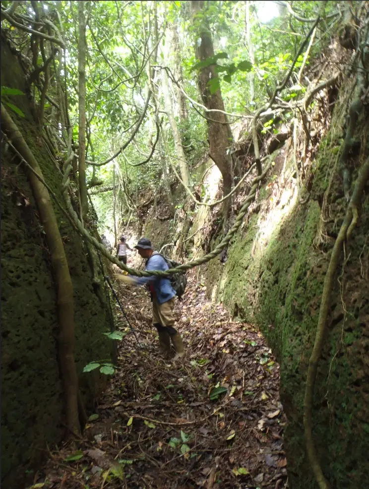
Image: Inside the Sungbo Eredo.jpg — Unknown author, CC0 · source
Hidden in the Ijebu forest is a ditch longer than the road from Lagos to Ibadan. Who dug it, and why?
You could walk through the forest near Ijebu-Ode and pass a few metres from the Eredo without knowing it was there. That is how the BBC's Barnaby Phillips described it after a trek in 2000. The bush hides it completely until the ground drops away in front of you. Then you are looking down into a great trench with smooth red walls, and if you climb down, the walls rise far above your head. In places the drop from the top of the bank to the floor of the ditch is about twenty metres, roughly the height of a six-storey building.
Down at the bottom it is cool and dim. Moss turns the walls green, trees lean in from both sides, and the light comes through the leaves in patches, so the whole thing feels like a long green tunnel. Eredo is the Yoruba word for this kind of earthwork, a ditch with a bank of the dug-out earth piled on its inner side.
And it goes on and on. The ditch makes an uneven ring around the old heart of the Ijebu kingdom, an area about forty kilometres across from north to south. Its full length is more than 160 kilometres. A team from William & Mary in the United States, which mapped it from the air with laser scanning, now puts it at about 170.
Every metre of it was dug by hand in laterite, a hard reddish soil full of clay and iron. There were no machines. Patrick Darling, the British archaeologist from Bournemouth University who walked its whole length and finished mapping it in 1998, said it must have needed a big, well-organised workforce following a master plan. In terms of sheer size, he told the BBC, it is the largest single monument in Africa, bigger than any of the Egyptian pyramids. The pyramids go up. The Eredo goes down. As the William & Mary historian Gérard Chouin put it, many of West Africa's great monuments push into the ground instead of rising out of it.
Ask the people of the area who dug it and they give you a name. Bilikisu Sungbo was a rich and powerful widow with no children, and the story goes that she had the ditch dug as a lasting memorial, something that would keep her name alive when she had no family to do it. Her grave is said to lie at Oke-Eiri, a village just north of the Eredo, and it has become a holy place. Thousands of Christians and Muslims come every year to pray there.
A reporter from The Nation newspaper went to see it. At the outer gate, which carries a faded sign reading "Her Majesty, Bilikisu Sungbo", the chief imam of Oke-Eiri, Ojulari Hamisu, took off his shoes and told the visitor to do the same, because from there on it was holy ground. A narrow path ran through thick forest to a long shed of corrugated iron. Under it, a white iron fence marked out the grave. Villagers say the busiest days are Eid-el-Kabir and Boxing Day, when cars fill the village and pilgrims come from all over, some from abroad. Women and dogs are not allowed in. The elders explained the ban with a story about a white man who came with his wife and his dog about a hundred years ago, and opened the grave anyway. The wife and the dog died soon after, they say, and the man himself died that same year. They say he photographed the body, and that it had not decayed.
Not everyone in Oke-Eiri believes this. The local Anglican vicar told The Nation the whole thing is a myth, and Tunde Odunlami, a historian at Olabisi Onabanjo University, said flatly that nobody has ever dug up the grave and that the famous photo is just an artist's sketch.
Then there is the biggest claim of all. Many pilgrims believe Bilikisu was the Queen of Sheba, who visited King Solomon in the Bible and the Quran, where she is called Bilqis. The Baale of Oke-Eiri, Olaitan Olugbosi, told the BBC that when she married Solomon she became Sheba. Darling himself said the idea could not be thrown out completely, though he added that the dates were the strongest argument against it. Sheba belongs to a time about three thousand years ago, some two thousand years before anyone started digging the Eredo.
So when was it dug, and why? Darling dated it to the tenth or eleventh century, which would make it about a thousand years old. He called it the earliest proof of a kingdom founded in the African rainforest. Newer excavations point later, to the end of the 1300s or the early 1400s, and Chouin links it to the Ijebu state that took shape in the late fourteenth century and lasted until the 1800s. Some carbon dates from the site are far older still, but those may date old soil rather than the digging itself, so the question is still open.
Most experts agree on what it was for. It marked out and protected a kingdom at a time when the towns of the rainforest were fighting and joining together. Darling also wondered aloud whether it was meant to keep elephants out. Chouin adds another reason. A ditch this big was a boast. Whoever ordered it was showing the world how many people they could put to work. "It was rich in people," he said.
In 1999 Darling's work made headlines around the world, but he warned that farming and tree-cutting were eating away at the walls, and that without protection the Eredo might not last more than another couple of decades. Nigeria had already put it forward to UNESCO in 1995, as part of a joint listing with the Benin earthworks, but it is still only on the tentative list.
The William & Mary team spent five years scanning about a thousand square kilometres of forest. They say it is the largest LiDAR survey ever done for heritage work in Africa, more than a terabyte of data in 1,772 map tiles. In August 2024 Chouin shared the results with about two hundred people at a workshop at Augustine University in Ilara, Lagos State, and he expects the analysis to take at least a decade more. What he has now, he says, is a record of exactly how the monument looks today, so future generations can see what they managed to save and what they let slip away.